City & Administration
The simplification, optimization, and automization of workflows and processes has played a crucial role for many years in administration. Among the key components are the development of extensions for geographic information systems and databases, optimized graphical user interfaces, and consulting when acquiring or developing GIS and webmapping applications and spatial data infrastructures. Furthermore we offer trainings via gis-trainer.de. Many of our courses have an English description, but do not hesitate to contact us to inquire about further topics.
Scope of services
- Installation and setup of GIS and database systems
- Development and setup of INSPIRE-compliant spatial data infrastructures (SDI)
- Development of open data portals
- Hosting of OGC Open Web Services (WMS, WFS, WCS, among others)
- Data analysis and visualization
- Automation of GIS processes with Python
- Development of ArcGIS and QGIS extensions and plugins
- Mapmaking and preparation of mapping templates
- Development and adjustment of databases, input masks, triggers, etc.
- Trainings via gis-trainer.de
- System advice, support in decision making, maintenance of software and applications
Project Examples
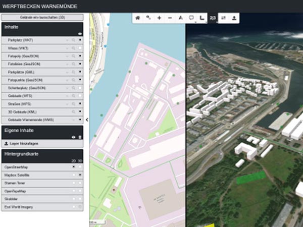
Development of a web-based map viewer for 2D and 3D data
geoSYS developed a 2D and 3D information system for sites and buildings.
The system not only visualizes 2D and 3D data in a map and a globe, but it also synchronizes both. The viewer allows users to upload data (including drag and drop functionality) of a variety of file formats (GeoJSON, Shapefile, KML, GML) and the connection to spatial web service standards, such as WMS, WCS, and WFS. When adding data formats that the browser cannot directly read (e.g. shapefile, GeoPackage) these datasets are converted server-side by GDAL / OGR or Python scripts; coordinate systems are transformed, if need be.
Access to the system is regulated by a complex user management, compromised of different roles that are granted to specific tables or columns in the database.
Client / Project Partners
INROS Lackner SE
Redevelopment of the BKG WebMap
The BKG WebMap developed for the Federal Agency for Cartography and Geodesy is a JavaScript library that provides various functions for a simplified generation of interactive maps. The BKG WebMap is based on OpenLayers 4.
Apart from various templates to easily integrate a map in personal web pages the BKG WebMap also exposes numerous tools that can be integrated comfortably, even for users with little to no programming knowledge.
Freely available services by the Federal Agency for Cartography and Geodesy can be used as basemaps. Apart from navigation and querying of layers and services the library also offers advanced search and measuring functionalities, digitizing, and the connection to web services as well as the uploading of data (GeoJSON, KML, GPX, WKT).
geoSYS also conducted trainings to introduce employees from the BKG to the new web map. Two different trainings were offered, one for users of the library, and one for developers who want to extend the source code with their own features.
Client / Project Partners
Bundesamt für Kartographie und Geodäsie (BKG)
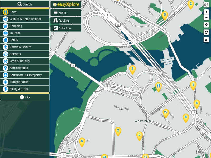
Development of the easyXplore Portal for Tourism
The easyXplore mapping application allows the online representation of regional data. Both a desktop and a mobile application have been developed to facilitate comfortable access to the data. Based on modern web technologies easyXplore enables attractive city and regional marketing.
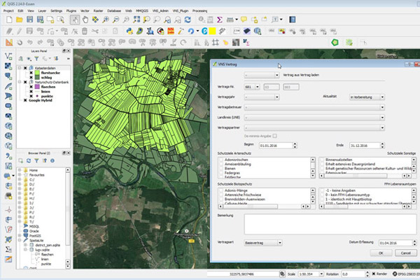
QGIS Plugin for conservation management agreements for the Landesamt für Umwelt in Brandenburg
geoSYS has created a QGIS plugin for the Landesamt für Umwelt, Gesundheit und Verbraucherschutz Brandenburg. The plugin's purpose is the administration of conservation management agreements. This new solution replaces the former PEP-GIS, which had to be used in ArcView.
The following points portray major components or functions of the plugin:
- Entry and maintainance of conservation management agreements
- Local saving of data and geometries in a SpatiaLite database
- Merging and synchronization of multiple local databases
- Automated and customizable SQL queries
- Import and export of central databases to local databases
- Automated creation of PDF documents, based on data entry
- 1-click creation of maps with point/line/polygon geometries
Client / Project Partners
Landesamt für Umwelt (Brandenburg)
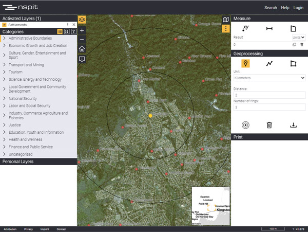
National Spatial Planning Information Technology (NSPIT) Platform, Jamaica
Funded by the World Bank, geoSYS was commissioned to develop the National Spatial Planning Information Technology (NSPIT) Platform for the Government of Jamaica. The NSPIT shall functions as a spatial data infrastructure to improve decision making in planning and national development, providing government agencies, educational institutions, the private sector, and citizens access to Jamaica’s spatial data. geoSYS was involved in every phase of the project, from its planning and development to deployment and training.
The NSPIT Platform has 5 components:
- NSPIT Viewer (view)
- NSPIT Data Portal (view)
- NSPIT Help Portal (view)
- QGIS Metadata Plugin
- ArcGIS Metadata Tool
Client / Project Partners
Planning Institute of Jamaica
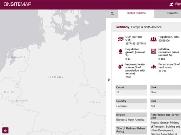
on-site-map
The on-site-map developed for ANCB (Aedes Metropolitan Laboratory) and UN-Habitat displays National Urban Policy Projects as well as countries and corresponding information from a World Bank API. The application covers worldwide information and includes a variety of attributes that describe projects as well as statistics portraying different countries. To improve accessibility a filter functionality is offered to search the data in the application (e.g. project value, duration, start/end data).
Client / Project Partners
ANCB, UN-Habitat
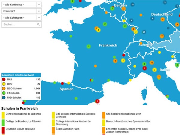
Redevelopment of the map-based application PASCH-net
Redevelopment of a webmapping application for the visualization of various German institutions and partner schools.
Client / Project Partners
Goethe Institut
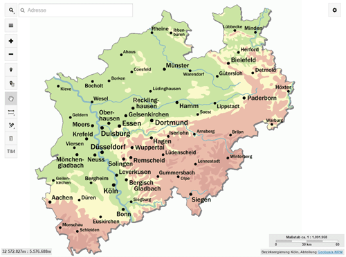
TIM-online
geoSYS redeveloped the application TIM-online for the state Nordrhein-Westfalen.
TIM-online provides surveying, cadatstral and spatial base data from NRW via Web Map Services (WMS). The application contains tools, such as GPS positioning, digitizing, measuring, and address searching. The application was optimized to run on mobile devices, so it can be accessed anytime from anywhere.
Client / Project Partners
Bezirksregierung Köln (Dezernat 74 - Geodatenzentrum, Geodateninfrastruktur)